
Whether you’re looking for directions or measuring the distance between landmarks, maps are an exceptional tool. Sometimes, they can even unlock richer histories than previously known.
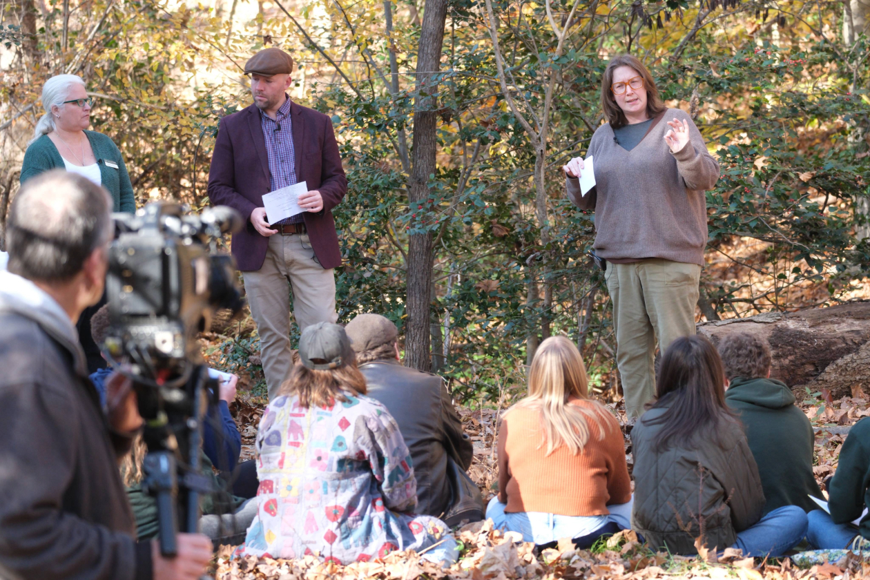
That was the case for Robyn Schroeder, a William & Mary faculty affiliate and National Institute of American History & Democracy assistant director, whose “The Revolutionary War at William & Mary” course in the fall walked students through Revolutionary War-era Williamsburg. As part of that class, students analyzed a centuries-old map of Williamsburg and explored different fields of research on campus during the war.
Schroeder aims to launch a tour of such Revolutionary War-era sites on campus in April 2026. The tour will detail notable events that occurred on campus from 1774 to 1781. Topics will include the closure of the Williamsburg Bray School, the raising of student militias in 1775 and 1777, the Fourth Virginia Revolutionary Convention hosted in the Wren Building and the preparations for the siege of Yorktown.
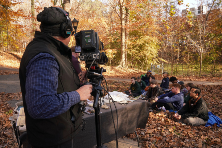
Schroeder’s work was featured on a Jan. 24 episode of the C-SPAN series “Lectures in History.” It also coincides with the country’s 250th anniversary and the university’s Year of Civic Leadership, which aims in part to celebrate William & Mary’s foundational role in establishing democracy in the United States.
“I’m a public historian because I believe we should try to tell everyone’s history of this place – everyone who was here then, for everyone who arrives here now,” said Schroeder. “I think that understanding that campus was bound up and, at times, central to much larger Revolutionary transformations, helps us to see William & Mary’s connections not only to the stories told in museums, but to the histories of the Revolution up and down the Eastern seaboard.”
Pinpointing the College Camp through the 1781 map
It all started with a map.
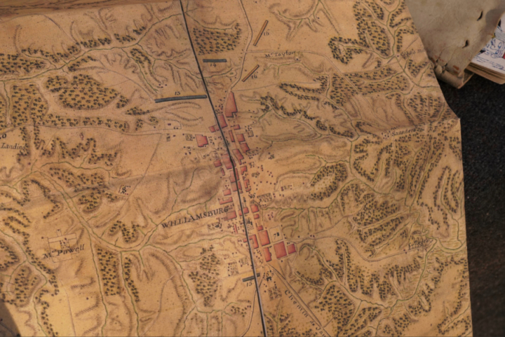
Using a map produced by French engineers under Jean-Nicholas Desandrouins to represent preparations for the September 1781 siege of Yorktown, Schroeder consulted with Shannon White, associate director of the Center for Geospatial Analysis, before her course to see how she could best present the map to her students and better understand its cartography.
A large focus throughout the class and the tour is the College Camp, which was used as a training ground for both militiamen and professional soldiers. It was in heavy use from the fall of 1775 to the spring of 1778, when it was likely superseded by a barracks built behind the Governor’s Palace.
“The College Camp was a hub,” she said. “I see it as a node of a network through which Virginians went to war, North and South, in the early years in ’75 to ’77, especially.”
The area was initially thought to be located immediately behind the Wren Building where the Sunken Garden is today. However, Schroeder posits that may not be the case. Using the map, she was able to identify where Henri de Saint-Simon and the Marquis de Lafayette’s forces were encamped in 1781 — a site on the high ground above College Creek, running alongside the site of the new West Woods complex. The map shows that the site was used by Lafayette in the weeks before the Battle at Yorktown, and by Saint-Simon’s artillery near Richmond Road on property the university doesn’t own.
Schroeder believes the military leaders would likely have chosen the abandoned site of the College Camp to use.
“That Lafayette’s position is marked on the map is the clue that lets us mark a much more likely location for the College Camp, a longer-standing and more important site of Revolutionary activity — in that it was a training ground and defensive position for thousands of soldiers and militia men,” said Schroeder.
White worked with fellows at CGA to overlap the roads and landmarks that still exist today, which provided a better understanding of where the College Camp may have been.
“The reason why the military chose that spot was because it was a high point, a dry point and close to water,” White said.
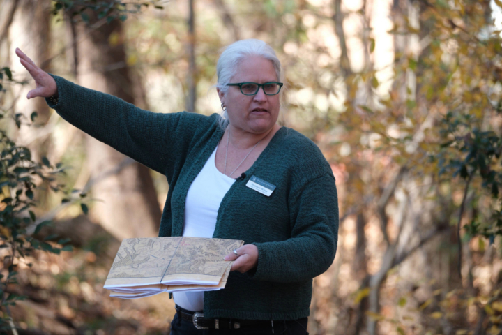
Centuries later, it’s much lower in elevation. “That’s something that’s really fascinating to think about from a historical perspective. … The university is constantly changing,” White added.
Schroeder’s research allowed her and her students to “correct the record,” and explain why the site was called the College Camp even though it’s on property which wasn’t owned by William & Mary at the time.
“My notion was that the access to water, high ground, location just past the contemporaneous boundaries of the college and the name ‘College Camp’ made sense, once we used the map to exclude the wooded thicket on the college side of College Creek,” Schroeder explained.
Locating the possible true location of the camp is significant because the camp itself was of major importance to the area’s role in the Revolutionary War.
“There were men whose entire pensionable military service in the Continental Army was service at and around the College Camp, defending the Fourth and Fifth Virginia Conventions and the city itself,” said Schroeder.
It was also a unique learning experience for the students in Schroeder’s class. Elizabeth Ott, a CGA fellow, put together the map that helped with location tracking. She began georeferencing her older map with the current Williamsburg landscape, pinning over 100 control points to overlay the university with existing rivers and roads. Her first time georeferencing a historical map, Ott noted that rivers were a difficult but rewarding challenge and that I-64 completely changed the geography from the old map.
“It was really fun to take skills I learned in my research at William & Mary and apply them to my position here,” she said. “I’m very happy to work with (Schroeder and White) on this.”
An intertwined history
Late last fall, with C-SPAN in tow, Schroeder’s class gathered behind the McLeod Tyler Wellness Center to place themselves where soldiers found themselves centuries ago. Materials found in a common soldier’s artillery were brought in from the Jamestown-Yorktown Foundation to provide a better grasp of camp conditions.
During the class, White challenged students to consider why maps were oriented the way they were, what changes were most notable to the landscape and what they would predict they could find in the historical record about the area.
For Tyler Lewis ‘26, a student in the class, it was an enriching experience. Students did their own research on the university during the Revolutionary era in the course, with Lewis focusing on the Williamsburg Bray School and its connections to the university.
“(This class) really shows just how intertwined the college was to the history of the Revolution in the city,” he said. “You can’t talk about the Revolution in Williamsburg without the college.”
Schroeder aims to drive that point home throughout her tour, which she and NIAHD students will lead. Tour dates will be announced in April, and people may sign up for them via an online form. No matter the people who trained at the College Camp, or the structures that were destroyed or the battles contested, Williamsburg is a central figure.
“The college hosted a cosmopolitan range (of people) running from backwoods Virginians, free and enslaved, to French aristocrats,” she said. “You can see very clearly what was at stake, up to and including people’s lives and people involved themselves in this war for complex reasons beyond taxation policy and sovereignty.”
William Oster, Communications Specialist